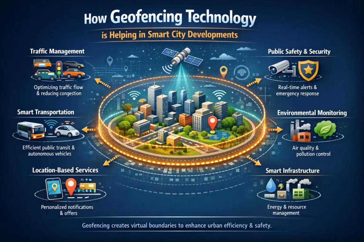
How Geofencing Technology Is Helping In Smart City Developments
Cities around the world are under relentless pressure — rising populations, traffic gridlock, energy waste, and public safety gaps that old-school infrastructure simply can’t fix. That’s exactly where geofencing technology steps in. It gives urban planners a powerful, invisible layer of intelligence that sits on top of city systems, triggering real-time responses the moment people or vehicles cross a defined boundary.
This blog breaks down exactly how geofencing works in real urban environments, which city systems benefit the most, and what the future looks like for smart city developments powered by location-based intelligence. If you manage urban infrastructure, work in municipal tech, or simply want to understand what’s reshaping cities today — you’re in the right place.
What Is Geofencing Technology, and Why Do Cities Need It?
Geofencing creates a virtual perimeter around a real-world geographic area. When a GPS-enabled device — a phone, a vehicle, a sensor — enters or exits that perimeter, it triggers a pre-set action. That action could be a push notification, a traffic signal change, an alert to emergency services, or a data log.
Traditional city management reacts to problems after they happen. Geofencing flips that model. It makes cities predictive and responsive. According to McKinsey’s Smart Cities report, cities that adopt data-driven tools can reduce emergency response times by up to 35% and cut energy costs by as much as 25%.
The technology relies on GPS, RFID, Wi-Fi triangulation, or cellular data to define and enforce those virtual boundaries — and it works at any scale, from a single city block to an entire metropolitan zone.
6 Key Areas Where Geofencing Is Transforming Smart Cities
1. Smarter Traffic Management
Traffic congestion costs urban economies billions every year. Geofencing helps cities fight back by creating dynamic traffic zones that respond to real-time conditions.
When a vehicle enters a congestion geofence zone, the system can automatically adjust signal timing, alert drivers to alternate routes via connected navigation apps, or trigger variable tolling. Cities like Amsterdam and Singapore already use adaptive traffic signal systems layered with geofencing data to cut average commute times significantly.
Emergency vehicle preemption is another major win. An ambulance or fire truck crossing a geofenced corridor can automatically turn traffic signals green along its route — shaving minutes off response times when every second matters.
2. Waste Management Optimization
Garbage trucks following fixed routes waste fuel and time. Geofencing-enabled smart waste management monitors fill levels in connected bins and routes collection vehicles only when and where they’re needed.
When a bin’s sensor triggers a “full” status within a geofenced collection zone, the fleet management system dispatches the nearest available truck. The result? Fewer unnecessary trips, lower emissions, and cleaner streets. Barcelona’s superblock initiative combined similar location-aware fleet logic to reduce urban vehicle traffic by over 20% in pilot areas.
3. Public Safety and Emergency Response
Geofencing gives police departments, fire services, and emergency management teams a situational awareness layer they’ve never had before.
When an incident occurs inside a geofenced perimeter, the system can automatically push alerts to all officers’ devices in the area, reroute patrol units, and flag high-density crowd zones before situations escalate. NIST’s public safety communications research highlights how location-aware dispatch systems are already reducing first responder errors and improving resource allocation.
Geofencing also plays a role in school and hospital safety zones — instantly alerting authorities if unauthorized vehicles enter restricted perimeters during specific hours.
4. Smart Parking Systems
Circling for parking accounts for roughly 30% of urban traffic in dense city centers. Geofencing eliminates the guesswork.
When a driver enters a parking geofence zone, the city’s connected parking app delivers real-time availability data and guides them directly to an open spot. Payment triggers automatically when the driver parks and departs the zone — no meters, no tickets, no wasted time.
Los Angeles has piloted LA Express Park, a sensor-and-geofencing system that cut traffic caused by parking searches by 15% in tested corridors.
5. Energy Grid Management
Power grids face peak demand surges that strain infrastructure and spike costs. Geofencing helps energy providers anticipate and manage those surges intelligently.
By mapping geofenced zones to known consumption patterns — an office district powering up at 8 AM, a sports stadium filling to capacity by 7 PM — smart grid systems pre-position resources and smooth demand curves. The International Energy Agency identifies location-aware demand response as one of the most cost-effective grid optimization tools available today.
Electric vehicle charging networks also use geofencing to manage load balancing, preventing localized grid stress when hundreds of EVs plug in simultaneously across a neighborhood.
6. Environmental Monitoring and Low-Emission Zones
Air quality is a public health crisis in many cities. Geofencing provides a clean enforcement mechanism for Low Emission Zones (LEZ) — areas where high-polluting vehicles face restrictions or charges.
London’s Ultra Low Emission Zone (ULEZ) uses geofenced boundaries to automatically identify and charge non-compliant vehicles. Transport for London reports a measurable drop in roadside nitrogen dioxide since the zone expanded. No physical checkpoints needed — just GPS data, vehicle registration databases, and a well-defined virtual boundary.
Environmental sensors inside geofenced zones also feed air quality data to city dashboards, enabling rapid policy responses when pollution spikes.
How Cities Actually Implement Geofencing: The Technical Side
Implementation starts with three layers working in sync: data collection, boundary definition, and action triggers.
Cities work with GIS (Geographic Information System) platforms to define boundaries, then integrate with IoT sensor networks, connected vehicle systems, and mobile device data streams. Platforms like HERE Technologies and Esri ArcGIS power much of the urban geofencing infrastructure in major metros today.
Privacy compliance is non-negotiable. Cities must anonymize location data in line with local regulations — GDPR in Europe, CCPA in California — and ensure data governance frameworks prevent misuse. The most successful programs communicate openly with citizens about what data they collect and why.
Real Cities, Real Results: Case Studies Worth Knowing
Singapore’s Smart Nation Initiative
Singapore integrates geofencing across its public transit network, autonomous vehicle test zones, and crowd management systems. The Smart Nation Singapore platform uses geofenced corridors to manage autonomous shuttle trials on public roads — automatically limiting speed and route deviation the moment a vehicle strays outside its defined path.
Dubai’s Smart City Blueprint
Dubai deploys geofencing as part of its broader Smart Dubai 2021 strategy, covering everything from tourist zone management to construction site safety monitoring. Geofences around active construction sites trigger instant alerts when unauthorized personnel enter, cutting worksite accidents measurably.
Kansas City, USA
Kansas City’s KC Streetcar corridor uses geofencing data to feed real-time arrival predictions and dynamically adjust traffic signals along the route. Ridership rose significantly after the system improved schedule reliability.
The Challenges Cities Still Face
Geofencing isn’t a plug-and-play solution. Cities still grapple with real obstacles:
Data privacy concerns top the list. Citizens resist location tracking without clear transparency and consent mechanisms. Cities that rush deployment without community trust-building face pushback that stalls projects entirely.
Infrastructure gaps also slow progress. Geofencing works best when the underlying city infrastructure — connected sensors, reliable internet coverage, integrated data platforms — already exists. Older cities with legacy systems face expensive upgrade cycles before geofencing delivers full value.
Finally, interoperability between vendor platforms remains messy. A traffic management system from one vendor rarely communicates cleanly with a waste management platform from another. Open data standards, like those promoted by FIWARE Foundation, are pushing the industry toward better compatibility.
What the Future Holds: Geofencing and Next-Generation Smart Cities
The next evolution of smart city infrastructure will combine geofencing with 5G networks, autonomous vehicles, and predictive analytics to create cities that genuinely self-regulate.
Imagine a geofenced school zone that automatically slows all autonomous vehicles within a 200-meter radius every morning between 7:30 and 9:00 AM — no human input required. Or a disaster response system that geofences an entire district within seconds of a seismic event, instantly rerouting all transit and pushing evacuation guidance to every device in the zone.
According to Gartner’s Smart City Technology Report, by 2027, more than 50% of major cities globally will use geofencing as a core component of their urban operations stack.
The cities that invest in this technology today aren’t just solving today’s problems. They’re building the infrastructure backbone for the urban environments of the next generation.
Conclusion: The Invisible Infrastructure Shaping Tomorrow’s Cities
Geofencing technology isn’t flashy. You can’t see it, and most residents never know it’s working. But it quietly orchestrates cleaner streets, faster emergency responses, smoother traffic, and lower energy bills across cities around the world.
For urban planners and municipal leaders, the question is no longer whether to adopt geofencing — it’s how fast to move and how smart to be about it. The cities investing in this invisible infrastructure today are the ones that will be genuinely livable, safe, and efficient tomorrow.
Start with one high-impact use case — traffic management, waste collection, or public safety — prove the model, then scale. That’s the approach that’s working.
FAQ: Geofencing Technology in Smart Cities
How does geofencing technology work in a smart city?
Geofencing in a smart city works by defining virtual boundaries around specific geographic areas using GPS, RFID, or cellular data. When a connected device — a vehicle, a smartphone, or an IoT sensor — enters or leaves that boundary, the system triggers a predefined action. That action could be a traffic signal adjustment, an alert to emergency services, or an automatic toll charge. Cities layer these geofences across dozens of systems simultaneously, creating a city-wide intelligence network that reacts to movement in real time.
What are the real benefits of geofencing for urban traffic management?
Geofencing helps cities manage traffic by enabling dynamic responses rather than relying on fixed signal schedules. When traffic builds up inside a geofenced zone, the system adjusts signal timing, alerts connected navigation apps, and reroutes vehicles — all automatically. Emergency vehicles crossing a geofenced corridor can get green signals cleared ahead of them, cutting response times. Cities using these systems report measurable drops in congestion and commute times, particularly in high-density corridors during peak hours.
Is geofencing in smart cities a privacy risk for residents?
Privacy is a legitimate concern, and cities must address it seriously. The best implementations anonymize location data, operate under strict data governance frameworks, and comply with regulations like GDPR or CCPA. Responsible smart city programs tell citizens exactly what data they collect, why they collect it, and how long they store it. Geofencing systems that operate transparently and use aggregate, anonymized data rather than individual tracking profiles can deliver full operational benefits without compromising resident privacy.
Which smart city systems benefit the most from geofencing technology?
Traffic management sees some of the fastest, most measurable improvements. Waste collection efficiency jumps significantly when geofenced routing replaces fixed schedules. Public safety benefits from geofenced alert systems that push real-time information to first responders. Environmental monitoring uses geofenced low-emission zones to reduce pollution without physical infrastructure. Smart parking eliminates the traffic caused by drivers searching for spots. Each of these systems works better in isolation — but when integrated, they create a city that operates as one connected, responsive system.